Index of All Cemeteries Alphabetical Index of All Burials Previous Page
Use the following to search across all the cemeteries listed.
Example: "Smith, Roger" (yes, use the quotes)
374 UNKNOWN CEMETERY

Location - Off Cracker's Neck Rd, Pilot Mtn., Surry Co., NC.
Coordinates: 36d 21m 14.5s N; 80d 32m 28.5s W Click here for Online Maps
Directions: From intersection of US Hwy 52 and NC Hwy 268 at Pilot Mountain, NC, go west on NC 268 for 4.1 miles and turn Left on Pilot Power Dam Road (SR 2044). Then go 1.8 miles and turn Left on Crackers Neck Road (SR 2046). Then go .8 mile to 275 Crackers Neck Rd on the left. Turn into drive at residence and upon exiting vehicle and facing house go to the Right (or south) and walk about 300 yds into a wooded area and will find an old farm trail and cemetery.
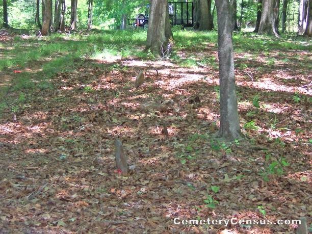
View #2 of cemetery. View #3 of cemetery. View #4 of cemetery. View #5 of cemetery. View #6 of cemetery. View #7 of cemetery. View #8 of cemetery.
Surveyed by Joe Hicks on May 11, 2008.
Township or district: Pilot.
Public or Private: Private property.
GPS Accuracy (ft.): 15.
Elevation above sea level (ft.): 833.
Status of cemetery: Forest area.
Surry County Parcel Number: 5945-00-51-7754.
No marked stones - just 4-5 fieldstones and appear to be children based on the length of the sunken areas. There at one time were pictures of the graves where someone had placed plastic flowers on the graves. Occupants unknown..
Web page updated 15 April 2021
Index of All Cemeteries Alphabetical Index of All Burials Previous Page
|
|
 |


