Index of All Cemeteries Alphabetical Index of All Burials Previous Page
Use the following to search across all the cemeteries listed.
Example: "Smith, Roger" (yes, use the quotes)
027 BLUE CEMETERY
Location - Turner Mountain Rd, Mt. Airy, Surry Co., NC.
Coordinates: 36d 25m 07.9s N; 80d 39m 31.9s W Click here for Online Maps
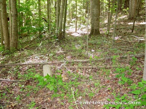
Directions: From intersection of US Hwy 52 and 601 in Mt. Airy, go south on US Hwy 601 (Rockford St) for 1.35 miles and turn left on Old US Hwy 601 and go 3.2 miles and turn left on Fireside Lane. Then go .3 mile and turn right on Turner Mtn Rd. Then go 1.2 miles to a pond on the left. Park on the north end of the pond (the end you first come to). Cemetery is on the right side of the road about 200 feet in the woods. After entering woods, bear slightly to the right and look for a small visible white stone.
Surveyed by Andy Hennis on May 6, 2006.
Township or district: Dobson.
Public or Private: Private property.
GPS Accuracy (ft.): 14.
Elevation above sea level (ft.): 1270.
Status of cemetery: Abandoned.
Surry County Parcel Number: 5917-00-15-7506.
There appear to be only two graves in this cemetery - one marked and one unmarked. The marked stone is for Nancy Cora Blue, born May 20, 1878, died May 18, 1880.
 Blue, Nancy Cora (b. 20 May 1878 - d. 18 May 1880) Blue, Nancy Cora (b. 20 May 1878 - d. 18 May 1880)
Web page updated 15 April 2021
Index of All Cemeteries Alphabetical Index of All Burials Previous Page
|
|
 |


