Index of All Cemeteries Alphabetical Index of All Burials Previous Page
Use the following to search across all the cemeteries listed.
Example: "Smith, Roger" (yes, use the quotes)
313 UNKNOWN [L00.1]
Location - Center Township. On Lower Haw River Natural Area land along Haw River, east side, west of SR 1714, Sugar Lake Road.
Coordinates: 35d 44m 57.6s N; 79d 07m 16.1s W Click here for Online Maps
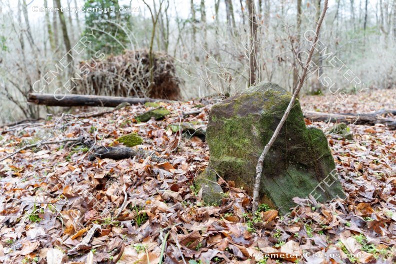
In 1999 Sarah Goddin and Scott Bryan reported an abandoned cemetery on what was then Duke University property adjoining their land. They noted about fifteen gravesites with unmarked stones. Goddin and Bryan revisited the site, which is now part of the Lower Haw River State Natural Area, on 5 Mar 2011 and found additional burials. There are three distinct groups of graves, separated by 20-30'. The first group has 16 graves, the second ten, and the third eight.
Click here to see a slide show of the various field stones in the cemetery.
Owner: State of North Carolina.
Legal Description: Parcel 74679. Deed 1076/109; plat 2003-138. Previously, deed 320-403, 28 Dec 1966, Tract Twentieth, Duke University.
Topo Quadrant: Merry Oaks.
Family owned: No.
Owner: Other, Unknown
Private: Other, Unknown
Abandoned: Yes.
Number of graves: 34
Cemetery size: 100' x 100'.
Restricted access: No, but difficult to access. Lies within Haw River natural area.
Overgrown and not easy to identify: Yes.
Enclosed: No.
Markers: Yes.
Markers with inscriptions: Yes.
Number of readable markers: 1.
Last burial: 1888.
First burial: 1888.
Markers damaged: Yes; time and weather.
Listed: Yes; Gravesites of Chatham County.
Miscellaneous information: In 1999 Sarah Goddin and Scott Bryan reported an abandoned cemetery on Duke University property adjoining their land. They noted about fifteen gravesites with unmarked stones. Accessible through property of Sarah Goddin/ Scott Bryan at 190 Ilex; Lot 21 of Subdivision, Phase Three, Plat 87-217. Last canvassed by: Will Heiser, Sarah Goddin, Scott Bryan. Date: 27 Mar 1999; revisited by Sarah Goddin and Scott Bryan, 5 Mar 2011. On their 2011 visit to the site, which is now part of the Lower Haw River State Natural Area, Goddin and Bryan found additional gravesites. There are three distinct groups of graves, separated by 20-30'. The first group has 16 graves, the second ten, and the third eight. One fieldstone marker has barely legible scratching that says "A.B. 1855." The site was revisited on 1 Feb 2020 by Chris Whitted who photographed the accessible grave markers. Whitted observed two sets of graves rather than three. The northern-most set had three rows of markers. Two rows were easy to get to, but fallen trees made the third row difficult to access.The only inscribed marker is in the second row. The inscription is clearly "A.B." and perhaps "1888." The second set of markers is just south of the first set by about 10 or 15 feet. This set did not seem as organized as the other set -- markers were a little farther apart and not in rows. Just beyond the second set were lots of large rocks in rows that could have been old walls. Nearby was a foundation. The area of the cemetery is very flat, yet on a hill. The river bank here is really high and a creek feeds into the river here.
Last canvassed by: Will Heiser, Sarah Goddin, Scott Bryan. Date: 27 Mar 1999; Sarah Goddin and Scott Bryan, 5 Mar 2011. Chris Whitted, 1 Feb 2020.
 Unknown, Unknown (b. Unknown - d. 1888) Unknown, Unknown (b. Unknown - d. 1888) Only stone inscribed with "AB 1888".
Web page updated 8 June 2021
Index of All Cemeteries Alphabetical Index of All Burials Previous Page
|
|
 |